20th August, 2016 – Just about four years ago a huge earthquake shook the heart of Italy. The epicentre of the earthquake was about 10 miles north-east of Norcia in the picturesque hills of Umbria. It is a beautiful region of forests, waterfalls and charming villages. It is the green heart of Italy, filled with farms, orchards and lush, productive fields. It is the place where the regions of Lazio, Umbria and Le Marche meet. The earthquake of four years ago was so strong it was felt in Rome, at least 100 kilometres from the earthquake zone. Every few years there is an earthquake in Italy that makes the news. Towns and villages in ruins fill our TV screens. There are many, many more earthquakes that don’t even make the news. Seismic activity in Italy is a continuing and constant story. This article aims to explain why…………..
The story continues…….
27th March, 2021: A series of earthquakes – at a depth of 10 kms below the surface. Centred in the Adriatic Sea off the coast of Puglia.
13th July, 2020: Udine – Forni di Sotto – an area just north-east of Venice is rocked by an earthquake – 9 kms below the surface of the Earth. It’s magnitude is 3.7, which means it will be felt by all those living within about twenty minutes of the tremor.
25th December, 2018: Seismic activity in and around Mount Etna, Sicily
28th January, 2017: The seismic activity in Italy which started in August, 2016 continues in Central Italy. Ten days earlier – 18th January there was an earthquake in Central Italy, the tremors and earth movement sent shock waves through the region, resulting in an avalanche that engulfed a hotel. The force of the avalanche displaced the hotel downhill by tens of meters. Almost thirty people lost their lives. This is all part of a continuing seismic pattern that has seen tens of thousands of quakes in Central Italy since August of last year.
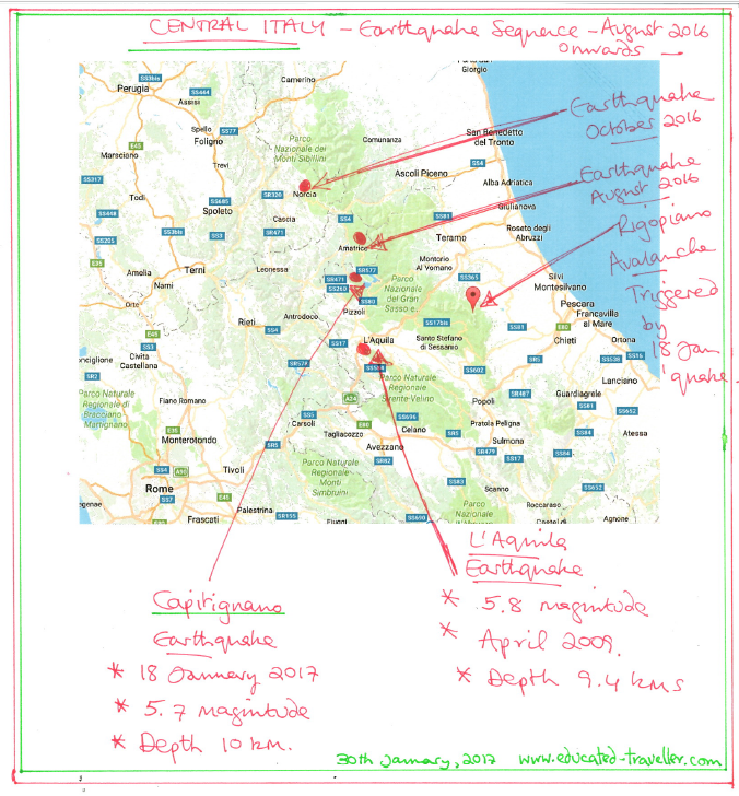
30th October, 2016: A series of earthquakes started in late August, in Italy’s central mountainous area, about two hours east of Rome. For several months Central Italy was jostled and rocked by thousands of tremors and several strong earthquakes. On 26th October, there was a large earthquake west of Visso, hundreds of people were evacuated to the coast for their safety. Then on the morning of 30th October, another huge earth tremor struck just to the north of Norcia, Umbria. This quake registered 6.6 on the Richter scale. Ever since the quakes have continued, shaking the hills and small towns of this mountainous area. I can’t even imagine how frightening and concerning these ground movements are for the local people. In fact the local people had to endure months of quakes and minor quakes, which eventually came to an end several months later.
24th August, 2016: Amatrice: The small town of Amatrice was severely damaged by a violent earthquake – hundreds of people lost their lives. Houses collapsed and roads destroyed.
For a lay person’s guide to Italy’s earthquakes:
Italy is a long peninsula of ancient rock that runs approximately north to south, from Austria and Switzerland to Sicily and the coast of North Africa. The Mediterranean Sea is a huge basin that is being gradually squeezed between the two gigantic continental plates of Europe and Africa. The backbone of Italy is a range of mountains called the Apennines. There is a tectonic fault line that runs down much of these mountains. If you think of the Earth’s surface as a series of plates moving in relation to one another, a bit like a 3-D puzzle or the bones that make up the skull of a new born baby, then you can visualise the edges of these plates, pulling apart in some places and pushing together in others. The plate boundaries are generally areas of construction or destruction. These plate boundaries are frequently associated with volcanoes and earthquakes. From the plate boundaries run fault lines, often at right angles to the plate edge, these fault lines complicate matters greatly. Pressure can build up along these fault lines until dramatic movement occurs which results in an earthquake. Movement along the San Andreas Fault in California is monitored constantly in an attempt to predict future quakes.


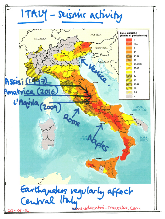
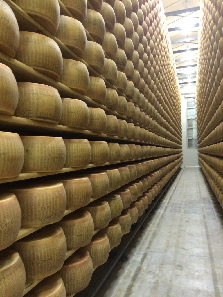
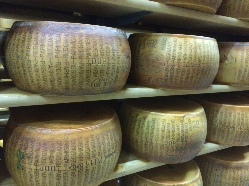
Italy’s fault lines are very active in geological terms. In the last twenty years there have been three major earthquakes and numerous smaller ones. The beautiful town of Assisi was hit in 1997 by a quake which damaged the famous Basilica of San Francisco. It took years to restore the church and it’s medieval frescoes. In 2009 there was a quake in L’Aquila which destroyed the town and killed hundreds of people. In 2016 an earthquake measuring 6.2 on the Richter scale destroyed Amatrice, a pretty little mountain town known all over Italy as the birthplace of a special pasta dish – Pasta al’Amatriciana. Not far from Modena in Emilia Romagna there was an earthquake in 2012 which shook the buildings so hard enormous wheels of Parmesan Cheese fell from the shelves in the drying houses where they are stored to age for ten to fifteen years.
So why do people live in ‘earthquake prone’ areas? Well they live here for many reasons. Volcanic rocks produce, over time excellent, fertile soils that are wonderful for farming. Let’s take Vesuvius as an example – this is a huge volcano, an active volcano, located on the Bay of Naples. It will probably erupt again at some point in the future. After Milan and Rome, Naples is one of Italy’s largest cities. In the event of a volcanic eruption there would be a massive ejection of gases and rock into the atmosphere. The vacuum created by the explosion would create very strong onshore winds as air rushes in to fill the void. These strong winds would prevent people leaving the area by sea. The motorway around the bay would become gridlocked within an hour with cars trying to flee. The result would be catastrophic. However people, especially Italians, love to be near family. Family connections and relationships bind individuals to a town, a village, even a street. Familiarity is reassuring it provides us with security and predictability.
As the Apennine Mountains have been contorted and twisted through geological time. So this has led to the formation of beautiful metamorphic rocks, especially the marbles of Carrara. The Carrara Marble quarries just north of Pisa have the finest, whitest marble. Famously used by Michelangelo when he sculpted ‘David’ in the 16th century. This Apennine marble was also used to decorate the Cathedral of Florence, interiors of palaces and aristocratic homes. Marble was brought from Pistoia, Prato and Carrara. Each town was known for the colour and perfection of its stones. Green from Pistoia, red from Prato and white from Carrara.
I’ve been working in Italy for thirty years. The Italians are resilient people. They will rebuild and they will survive. The Italian peninsula is one of the most beautiful, rich and diverse landscapes of Europe. This is the land of olive oil, fine wines, cheeses, hams and delicious fruits and vegetables. A land of skill, design and ingenuity. A land of literature, art and culture. A land of profound humanity and kindness. Italy will endure and we can support the Italians by continuing to visit and showing that we care.
Notes:
- Livello di pericolosita in Italian means ‘level of danger’ in English.
- The USGS – United States Geological Survey does an excellent job monitoring seismic activity globally. It also has an informative web site, full of detail and live up-dates. The address is www.usgs.gov
- In Italy there is a National Centre for Earthquakes showing quakes and tremors, their location, depth and power – it is called INGV and provides extensive information on seismic activity. Italy’s ‘live’ seismic activity monitoring service
- The INGV – Italy’s National Seismic Monitoring service also produces live updates of all measurable seismic activity. Here’s more from the recent Udine quake of July 2020 – INGV link: https://bit.ly/32gIMGn
- The Volcanic Eruption of Mount Vesuvius, Bay of Naples in 71 AD changed the shape of the mountain and covered the towns of Herculaneum and Pompeii in pyroclastic material, ash and debris, to a depth of more than a hundred metres. Vesuvius – volcanic eruption, Herculaneum & Pompeii

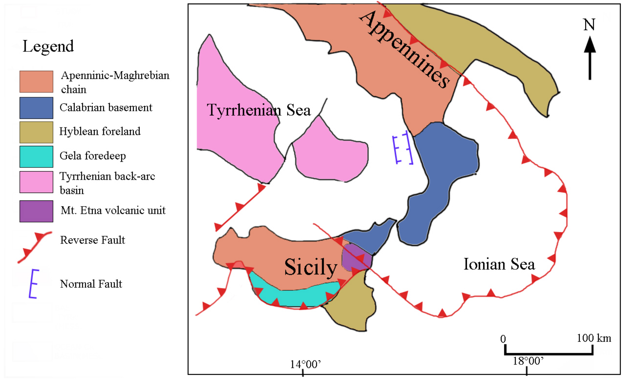
- These maps of Sicily and the volcano of Etna, show clearly the fault lines that cause seismic activity in Southern Italy and Sicily.
- Inspired by recent eruptions down the south-east flanks of Etna (Sicily) read this article: https://wp.me/p5eFNn-63m
- Updated: 30-10-2016
- Updated: 29-01-2017
- Updated: 26-10-2018
- Updated: 24-01-2019
- Updated: 20-07-2020
- Updated: 28-03-2021
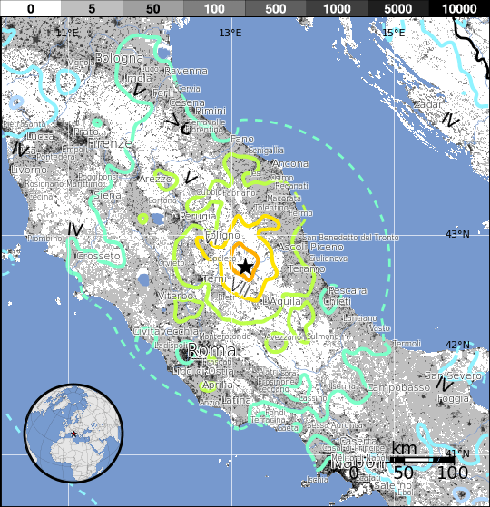
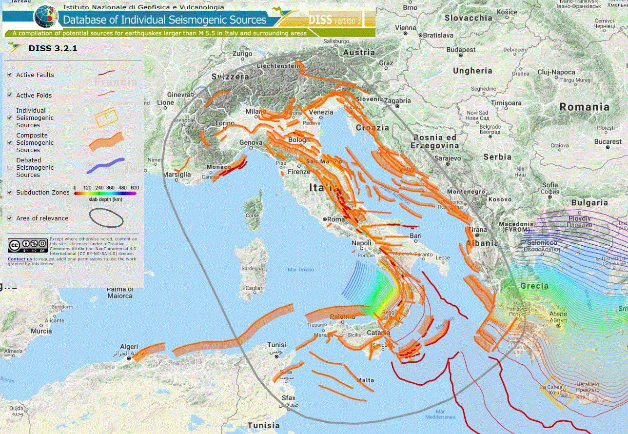
A fantastic and detailed ‘seismic map’ published in late 2018 by Italy’s INGV:
Most recently updated: 27-03-2021

Ah…finally! An explanation of earthquakes written in a simple way that I can understand! And I love your diagram, Janet! Thank you!
LikeLiked by 1 person
My thoughts and prayers are with them all. The sadness is overwhelming.
LikeLiked by 1 person
So True about The Italians and their Resilience! Kind Hearted People. Thank you for a wonderful article
LikeLiked by 1 person
Just watching RAI news now – earthquakes keep happening in Central Italian – 5000 people heading for coast and temporary shelters in hotels and public buildings – poor people.
LikeLike
Saved as a favorite, I really like your blog!
LikeLiked by 1 person
thank you kindly
LikeLike
Greatt read thanks
LikeLiked by 1 person